Article
from Political Geography

What We Don't See: Uncovering Intercommunal Violence Through Remote Sensing

Earth observing remote sensing technology offers a pioneering method for gathering data on collective violence that would otherwise remain unseen, unreported, and unrecorded. However, it remains a critically underutilized tool in the academic study of conflict.

READ FULL ARTICLE
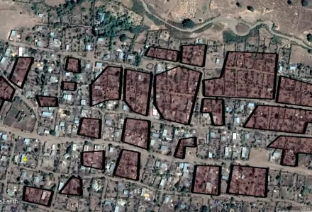
Visual evidence of significant structural destruction in town in the Konso Zone captured.
Visual evidence of significant structural destruction in town in the Konso Zone captured. Fire data captured by VIIRS suggests the destruction occurred on 17 November 2020.  
Key Takeaways
  1. Scholarship on political conflict relies to a large extent on data coded from news reports. While this has allowed for progress in cross-national studies of  conflict, it also means that biases in news reports can carry over into research. Some forms of violence are severely underreported, and this applies especially to intercommunal violence which is often overshadowed by other forms of conflict such as civil wars.  
  2. Remote sensing can, under the right circumstances, allow scholars to gain significant insight into the micro-dynamics of violence in low-information contexts where field work may be difficult due to issues of safety and costs. This article focuses on satellite-gathered fire data, in particular, and uses anomalous fire patterns to detect unreported instances of violence against civilians. 
  3. Looking at two bouts of intercommunal violence in Cameroon's Far North Region in December 2021, and in Ethiopia's Southern Nations, Nationalities, and Peoples' Region (SNNP) in November 2020, I find evidence for the destruction of dozens of settlements, almost all of which were previously unreported. This strongly suggests that reporting bias is leading us to underestimate the impact of some conflicts on civilian communities, and remote sensing can allow conflict scholars to address this issue. 

ABSTRACT

Earth observing remote sensing technology offers a pioneering method for gathering data on collective violence that would otherwise remain unseen, unreported, and unrecorded. However, it remains a critically underutilized tool in the academic study of conflict. This article demonstrates the value added of remote sensing by outlining a method that relies on publicly available satellite data of fires in conjunction with other satellite imagery to gain insight into bouts of intercommunal violence, which are subject to reporting bias. I use anomalous fire patterns as leads to identify potential conflict events and satellite images to determine the conflict relevance of fire detections by analyzing structural damage and scorch marks. I illustrate the contribution of this method by applying it to two cases of intercommunal violence: one in Cameroon's Far North Region and the other in Ethiopia's Southern Nations, Nationalities, and Peoples Region. I find 28 destroyed settlements in the former case, and 14 in the latter, most of which were previously unreported. Finally, the method has important academic and humanitarian use cases as a low-cost way of gaining near real-time and spatiotemporally accurate insight into the extent and spread of violence in conflict vulnerable areas.

Recommended citation

Naghizadeh, Mikael. “What We Don't See: Uncovering Intercommunal Violence Through Remote Sensing.” Political Geography, January 2025

Want to read more?

The full text of this publication is available via Political Geography.